


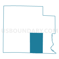
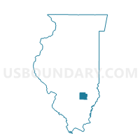
STANFORD Voting District, Clay County, Illinois
About
Outline

Summary
| Unique Area Identifier | 564906 |
| Name | STANFORD Voting District |
| County | Clay County |
| State | Illinois |
| Area (square miles) | 53.04 |
| Land Area (square miles) | 52.98 |
| Water Area (square miles) | 0.07 |
| % of Land Area | 99.87 |
| % of Water Area | 0.13 |
| Latitude of the Internal Point | 38.67159880 |
| Longtitude of the Internal Point | -88.41739070 |
Maps

Graphs
Select a template below for downloading or customizing gragh for STANFORD Voting District, Clay County, Illinois


Neighbors
Neighoring Voting District (by Name) Neighboring Voting District on the Map
- CLAY CITY I Voting District, Clay County, IL
- CLAY CITY II Voting District, Clay County, IL
- HARTER I Voting District, Clay County, IL
- HARTER II Voting District, Clay County, IL
- HARTER VI Voting District, Clay County, IL
- HARTER VII Voting District, Clay County, IL
- HOOSIER Voting District, Clay County, IL
- KEITH TWP Voting District, Wayne County, IL
- LOUISVILLE I Voting District, Clay County, IL
- PIXLEY I Voting District, Clay County, IL
Top 10 Neighboring County Subdivision (by Population) Neighboring County Subdivision on the Map
- Harter township, Clay County, IL (6,394)
- Louisville township, Clay County, IL (1,662)
- Clay City township, Clay County, IL (1,287)
- Stanford township, Clay County, IL (599)
- Pixley township, Clay County, IL (589)
- Keith township, Wayne County, IL (392)
- Hoosier township, Clay County, IL (338)
Top 10 Neighboring Place (by Population) Neighboring Place on the Map
Top 10 Neighboring Unified School District (by Population) Neighboring Unified School District on the Map
- Flora Community Unit School District 35, IL (8,201)
- North Clay Community Unit School District 25, IL (3,867)
- Clay City Community Unit District 10, IL (2,315)
Top 10 Neighboring State Legislative District Lower Chamber (by Population) Neighboring State Legislative District Lower Chamber on the Map
Top 10 Neighboring State Legislative District Upper Chamber (by Population) Neighboring State Legislative District Upper Chamber on the Map
Top 10 Neighboring 111th Congressional District (by Population) Neighboring 111th Congressional District on the Map
Top 10 Neighboring Census Tract (by Population) Neighboring Census Tract on the Map
- Census Tract 9721, Clay County, IL (5,405)
- Census Tract 9550, Wayne County, IL (4,360)
- Census Tract 9722, Clay County, IL (3,049)
- Census Tract 9720, Clay County, IL (2,844)